The total size of Jamaica is 4243.65 sq miles.
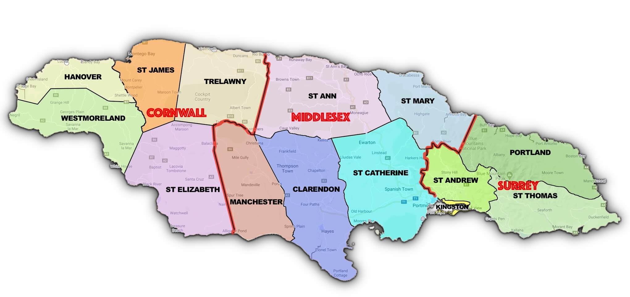
Jamaica has 14 parishes distributed across 3 counties: Cornwall, Middlesex and Surrey. All 14 parishes extend from the coastline surrounding the island, rising in elevation towards the interior. The highest mountain ranges, the Blue and John Crow Mountains, are in the easternmost region.
The parishes of Kingston and St Andrew were incorporated into a single andministrative entity called the Kingston and St Andrew Corporation (KSAC), with a single elected council and mayor in 1923. A brief history is provided below of each parish, along with their sizes, population, the length of their coastlines.
| Counties | ||||
|---|---|---|---|---|
| Cornwall | Middlesex | Surrey | ||
| Parishes | ||||
| Hanover | St. Ann | Portland | ||
| St. James | St. Mary | St. Thomas | ||
| Trelawny | Manchester | St. Andrew | ||
| Westmoreland | Clarendon | Kingston | ||
| St Elizabeth | St. Catherine | |||
| Capital | Population | Area | Coastline | Elevation | County |
|---|---|---|---|---|---|
| May Pen | 247,112 | 1,196km²/462mi² | 93.35km/58mi | 748m / 2454ft | Middlesex |
Ranked as Jamaica's third largest parish, Clarendon was named in honor of the Lord Chancellor Sir Edward Hyde, Earl of Clarendon. The parish was formed from a combination of three parishes: St. Dorothy's, Vere and the old parish of Clarendon. Before the merger, the capital was Chapelton.
| Capital | Population | Area | Coastline | Elevation | County |
|---|---|---|---|---|---|
| Lucea | 72,519 | 450km²/174mi² | 95.28 km/59.2mi | 391m / 1283ft | Cornwall |
Established on November 12, 1723, and given the family name of the English monarch, George I, who was from the House of Hanover in Germany. In the early colonial days, Lucea, the main town, was an even busier town than Montego Bay. By the mid-18th century, Lucea was the hub of an important sugar growing region and the town was prosperous as a sugar port and market center. Jews from Europe settled in the parish as merchants, store keepers, haberdashers, shoe makers and goldsmiths.
| Capital | Population | Area | Coastline | Elevation | County |
|---|---|---|---|---|---|
| Kingston (Downtown) | 90,544 | 22km²/8mi² | 62.40km/38.77mi | 337m / 1106ft | Surrey |
A parish consisting of old downtown Kingston and Port Royal, once known as the richest and most wicked city in the world. This parish was incorporated with St Andrew into a single andministrative entity called the Kingston and St Andrew Corporation (KSAC), with a single elected council and mayor in 1923.
| Capital | Population | Area | Coastline | Elevation | County |
|---|---|---|---|---|---|
| Mandeville | 191,720 | 830km²/320mi² | 34.28km/21.3mi | 898m / 2946ft | Middlesex |
Formed in 1814 by an Act of the House of Assembly, the parish was an amalgamation of the parishes St. Elizabeth, Clarendon and Vere. The amalgamation was done in response to a petition from the inhabitants of Mile Gully, May Pen and Carpenters Mountain who complained that they were too far away from an administrative center. Manchester was named in honor of the Duke of Manchester, the then Governor of Jamaica. He was governor for 19 years, setting the record as the longest serving Governor of the island. The capital town, Mandeville, established in 1816, was named after his eldest son, Lord Mandeville.
| Capital | Population | Area | Coastline | Elevation | County |
|---|---|---|---|---|---|
| Port Antonio | 80,921 | 814km²/314mi² | 113.79 km/70.7mi | 2257m / 7402ft | Surrey |
Noted for its fertile soil, beautiful scenery, and fine beaches. Portland, named after the Duke of Portland, governor of Jamaica when the parish was created in 1723, lies in the direct path of the northeast trade winds and the Blue Mountain ridge to its south traps the moisture causing the parish to have the highest rainfall in the island. Port Antonio, its chief town and capital, has two harbors, the western one being sheltered by a small islet, Navy Island. Portland covers an area of 814 square kilometers, making it Jamaica's seventh largest parish.
The parish has a variety of complex landforms; the entire coastline is dotted with caves, bays, rivers, waterfalls and hills. It is home of the only known extinct volcano on the island, located between the districts of Rodney Hall and Hopewell, close to the Rodney Hall Cave in the Black Hills. There are fourteen caves, which include those at Buff Bay, Orange Bay, Hope Bay, Port Antonio, Boston Bay, Long Bay, Innis Bay and Nonsuch. There are also 17 rivers which form a network throughout the parish. The largest are the Rio Grande, Buff Bay and Hectors Rivers.
| Capital | Population | Area | Coastline | Elevation | County |
|---|---|---|---|---|---|
| Half Way Tree | 571,947 | 431km²/166mi² | 30.64km/19.04mi | 1353m / 4439ft | Surrey |
St. Andrew was one of the first parishes to be established by law in 1867. It was originally knows as Liguanea before being established as the parish of St Andrew.
It lies just north of Kingston, bounded in the west by St. Catherine, north by St. Mary, northeast by Portland along the Blue Mountain range, and east by St. Thomas. In 1923, the parishes of St Andrew and Kingston were administratively merged to form the Kingston and St Andrew Corporation (KSAC), with a single elected council and a mayor. The geographic area of the KSAC is often referred to as the "Corporate Area."
Cross Roads, New Kingston, Half-Way-Tree, Matilda's Corner, and Constant Spring are important commercial centers in St. Andrew, but may be regarded as suburbs of Kingston. West St. Andrew, however, is a populous residential area.
| Capital | Population | Area | Coastline | Elevation | County |
|---|---|---|---|---|---|
| Saint Anns Bay | 177,054 | 1,213km²/468mi² | 62.77 km/39mi | 651m / 2136ft | Middlesex |
One of the oldest populated areas in the island of Jamaica tracing back to 600 - 650 A.D. It is believed to be the earliest Taino/Arawak settlement in Jamaica. When Christopher Columbus first came to Jamaica in 1494, he landed on the shores of St. Ann. He returned to Jamaica on his fourth voyage and was eventually marooned for one year at St. Ann's Bay (June 1503 - June 1504), which he called Santa Gloria. The first Spanish settlement in Jamaica was also at Sevilla la Nueva, now called Seville, just west of St Ann's Bay. Established by Juan de Esquivel, the first Spanish Governor of Jamaica, St Ann's Bay became the third capital established by Spain in the Americas. The first sugar mills were established by the Spaniards in Sevilla la Nueva before 1526.
After 1655, when the English captured Jamaica, St Ann's Bay gradually developed as a fishing port with many warehouses and wharves. The parish of St. Ann was later named after Lady Anne Hyde the first wife of King James II of England. Ocho Ríos began to develop as a modern town and a favorite tourist destination in Jamaica. Its development commenced when Reynolds Jamaica Mines built a deep-water pier, west of the town to ship bauxite ore from the mines.
| Capital | Population | Area | Coastline | Elevation | County |
|---|---|---|---|---|---|
| Spanish Town | 520,8045 | 1,192km²/460mi² | 104.13km/64.7m | 910m / 2986ft | Middlesex |
Jamaica's fourth-largest parish, the south of the parish is virtually flat except for the Hellshire Hills near the coast. The central and northern sections are very mountainous, however; the northern border is on Mount Diablo, which crosses over into St Ann, the highest point being 686 metres (2,700 ft).
| Capital | Population | Area | Coastline | Elevation | County |
|---|---|---|---|---|---|
| Black River | 151,911 | 1,212km²/468mi² | 70.33km/43.7mi | 613m / 2011ft | Cornwall |
Saint Elizabeth, the second largest parish, originally included most of the south-west part of the island, but in 1703 Westmoreland was taken from it and in 1814 a part was annexed to Manchester. The resulting areas were named after the wife of Sir Thomas Modyford, the first English Governor of Jamaica.
There are also traces of Taínos/Arawaks existence in the parish, as well as Spanish settlements. After 1655, when the English settled on the island, they concentrated on planting sugar cane. Today, buildings with 'Spanish wall' (masonry of limestone sand and stone between wooden frames) can still be seen in some areas.
St Elizabeth became a prosperous parish and Black River an important seaport. In addition to shipping sugar and molasses, Black River became the center of the logging trade. Large quantities of logwood were exported to Europe to make a Prussian-blue dye which was very popular in the 18th and 19th centuries.
| Capital | Population | Area | Coastline | Elevation | County |
|---|---|---|---|---|---|
| Montego Bay | 191,737 | 595km²/230mi² | 49.25km/30.6mi | 212m / 696ft | Cornwall |
Saint James was named by Sir Thomas Modyford, the island's first English Governor in honor of James, Duke of York, later King James II of England. The capital, Montego Bay, was an export point for lard, which was obtained from wild hogs in the forests during the years of Spanish occupation. In many of the Jamaica's early maps, Montego Bay was listed as "Bahia de Manteca" (Lard Bay). At the beginning of the English rule, the parish was one of the poorest; it had no towns, few inhabitants and little commerce, except for the exported lard. However, after the treaty with the Maroon in 1739, St James became one of the most important sugar producing parishes. Annually, more that 150 ships arrived in Montego Bay bringing slaves and supplies, and taking sugar. Commerce developed as wealthy merchants and planters erected many elaborate town houses. In 1773 Montego Bay had the only newspaper outside of Kingston - The Cornwall Chronicle.
A fire, in 1795 and again in 1811, destroyed many parts of Montego Bay. After being rebuilt, it was again destroyed in 1831 by a rebellion led by Sam Sharpe. This rebellion was as a result of the slave owner's reluctance to free the slaves, even after England proposed that they end slavery. Sam Sharpe, at first, tried to advocate passive resistance, but a group of slaves became violent and began setting fire to buildings and the surrounding plantations and cane fields. As a result of being the main planner of the rebellion, Sam Sharpe was hanged in the Montego Bay market place, which is today known as Sam Sharpe Square.
St James parish is home to several Great Houses, or Plantation Houses, built at a time when sugar cane made Jamaica the wealthiest English colony in the West Indies. Today, the Greenwood Great House is one is the most authentic. It is not featured in many tourist brochures but it is well preserved and well worth the visit, a hidden treasure of a national monument due to its history and the enduring presence of antique items.
After emancipation in 1834, the fortunes of the town and parish declined until the banana trade was promoted by J E Kerr and Co. This prompted the start of tourism in Jamaica. A Freeport was constructed in the 1960s, and later, a cruise ship terminal was opened. Montego Bay was accorded city status on May 1, 1980. The Sangster International Airport, one of the two on the island, is the hub for the national airline, Air Jamaica.
| Capital | Population | Area | Coastline | Elevation | County |
|---|---|---|---|---|---|
| Port Maria | 115,090 | 611km²/236mi² | 73.65 km/45.76mi | 920m / 3018ft | Middlesex |
Saint Mary was one of the first sections of the island to be occupied by the Spaniards. Puerto Santa Maria, later Port Maria, was the second town the Spaniards built on the island. In 1655, after the English captured Jamaica from the Spanish, the area around the north coast town of Santa Maria became known as St. Mary, with the chief town called Port Maria.
There are indications of strong resistance to slavery in the parish. The Easter Rebellion led by Tacky in 1760 and the existence of the Maroons at Scotts Hall showed that the parish was one of the most active in the fights for freedom. Its present size was determined in 1867, when the parish of Metcalfe was merged with St Mary.
| Capital | Population | Area | Coastline | Elevation | County |
|---|---|---|---|---|---|
| Morant Bay | 94,391 | 743km²/287mi² | 96.08km/59.7mi | 1505m / 4938ft | Surrey |
The parish of Saint Thomas was densely populated by the Tainos/Arawaks when Christopher Columbus first came to the island in 1494. The Spaniards established cattle ranches at Morant Bay and Yallahs. In 1655, when the English captured Jamaica, residents from other British colonies were invited to settle there. About 1600 colonists, mainly from Nevis, including the Governor of Nevis, his wife, children, settled there. In a short time, however, two-thirds of them died of fevers.
In 1674, the French Admiral Du Casse, sailed from Santo Domingo and landed at Morant Bay on June 17. For a month, he wrought havoc on the settlers there, killing many and carrying off their slaves. Later, bands of Maroons settled in the mountains of St Thomas and they eventually joined with the Maroons in Portland to form the Windward Maroons.
| Capital | Population | Area | Coastline | Elevation | County |
|---|---|---|---|---|---|
| Falmouth | 78,487 | 875km²/338mi² | 47.64km/29.6mi | 832m / 2730ft | Cornwall |
In 1770, the wealthy planters in St James and St Ann succeeded in having sections of those parishes become the parish of Trelawny as they were too far from administrative centers. Trelawny was named after William Trelawny, the then Governor of Jamaica. The first capital was Martha Brae located two miles inland from Rock Bay.
Trelawny is best known for its sugar estates and sugar factories. It had more sugar estates than any other parish, so there was need for a sea coast town to export it. Falmouth became a thriving seaport and social centre. The town had two of its own newspapers; The Falmouth Post and The Falmouth Gazette.
The town of Falmouth, with its sugar plantations, rum-making and shipping, grew into a major center of commerce and industry in the late 17-, to early, 1800s, thanks in part to several plantation owners such as John Tharp, whose operation was one of the largest on the island. The town rose in prominence around the world with an economic boom that led to the town's ascendance to being one of the most industrial towns in the Western Hemisphere. The town received running water before New York City, and it's meticulous planning illustrated one of the earliest example of urban planning developments.
Trelawny was also home to the largest group of Maroons in the island. A 1739 treaty between the Maroons and the English gave the Maroons freedom and land, which effectively put a stop to their raids on the plantations. However, a second Maroon uprising in 1795, led to over 600 Maroons being exiled to Nova Scotia, Canada and later to Sierra Leone in Africa in 1800.
| Capital | Population | Area | Coastline | Elevation | County |
|---|---|---|---|---|---|
| Savanna-la-Mar | 149,857 | 807km²/312mi² | 88.36 km/54.9mi | 469m / 1539ft | Cornwall |
Named after the county in England, and because it was the most westerly point in the island. One of the first Spanish settlements was built at what is now Bluefields in this parish. Savanna-la-Mar, a town by the coast, replaced Banbury as the capital in 1730.
In 1938, riots at the Frome sugar estate, changed the course of Jamaica's history. The changes that came in the wake of these riots led to universal adult suffrage in 1944, as well as a new constitution, which put Jamaica on the road to self government and eventual independence. The two national heroes, Sir Alexander Bustamante and Norman Washington Manley, emerged as political leaders during this time.